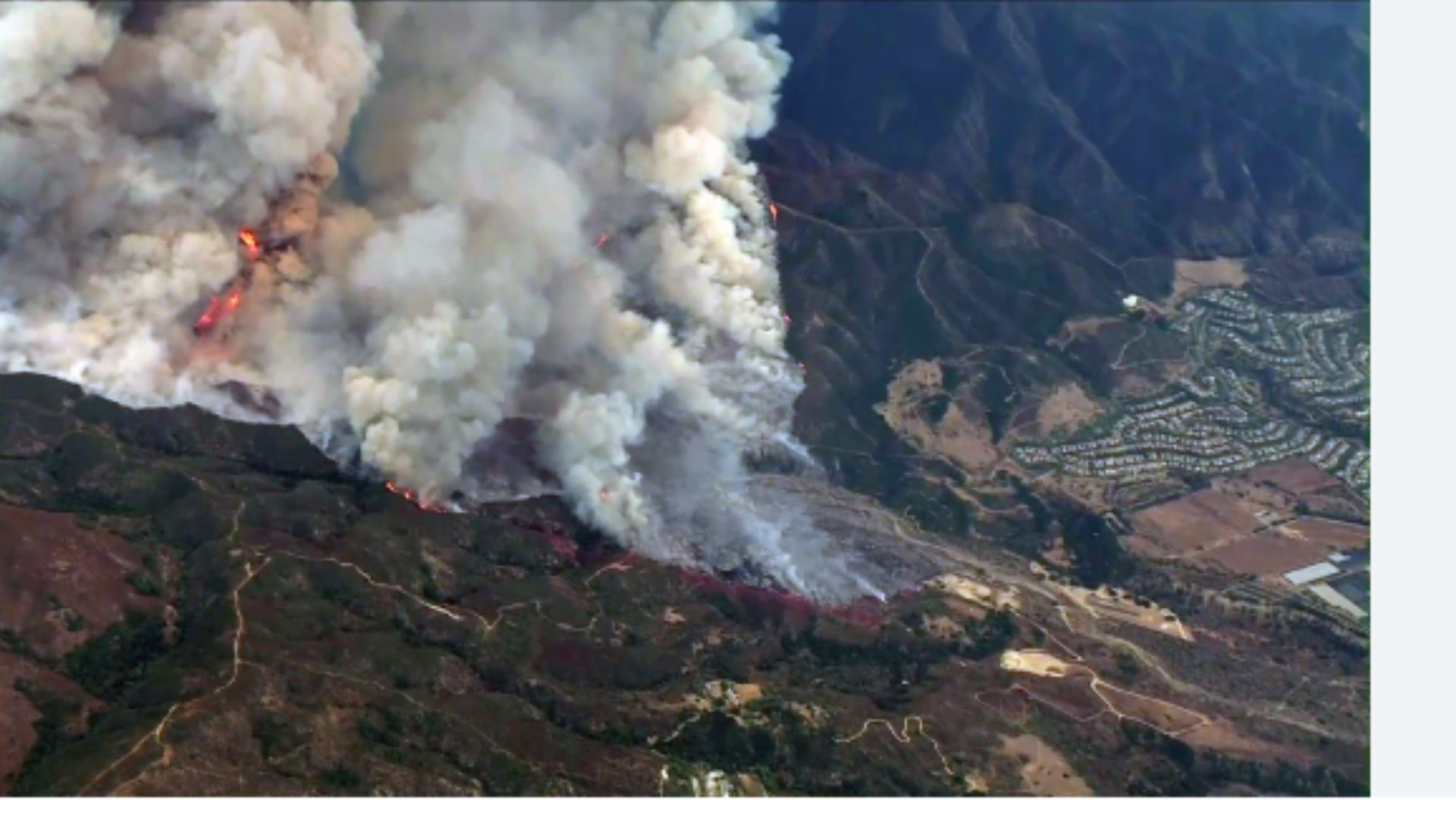
On Monday, Orange County firefighters hurried to Trabuco Canyon to extinguish flames burning vegetation on the hillside. The fire soon spread, engulfing more than 5,400 acres and causing thousands of people to abandon their homes. The Orange County Fire Authority named it the Airport Fire because it began near a remote-controlled aviation airport on Trabuco Creek Road.
Evacuations and road closures:
The Orange County Sheriff’s Department issued a voluntary evacuation alert for those who live nearby.
- Rose Canyon Road
- Trabuco Canyon Road
- Trabuco Creek Canyon Road
- Trabuco Oaks Drive
- Joplin Loop – Cook’s Corner
The department issued an evacuation order for homes along Meander Lane, including:
- Robinson Ranch HOA
- Trabuco Highlands HOA
- Trabuco Highland Apartment Complex
Firemen asked that people avoid the area so that firemen could respond effectively. Deputies have closed the following roads:
- Plano Trabuco & Joshua Drive
- Plano Trabuco and Robinson Ranch
- Antonio y Alas de Paz
- Trabuco Canyon and Creek
- Santa Margarita and Antonio, Avenida Empresa, and Santa Margarita Parkway.
Authorities set up a long-term automobile and reception shelter at the Bell Tower Regional Community Center, 22232 El Paseo, Rancho Santa Margarita, 92688. A big animal shelter has opened at 88 Fair Drive in Costa Mesa. Santiago High School, located at 1395 E. Foothill Parkway in Corona, serves as an evacuation hub for Riverside County residents. Animals can also be transported to that site.
Fast-moving Flames
Cal Fire said the Airport Fire grew from 7 to more than 5,400 acres in just eight hours. However, the OCFA reported that the fire spread uphill and away from residences.
Riverside County Impact:
Later Monday, the Riverside County Fire Department issued evacuation warnings for residents on the other side of the Santa Ana Mountains, including:
- RVC zones: 1153, 1265, 1267, 1269, 1395, 1396, 1397, 1398, 1399, 1400, 1401, 1402, 1403, 1405, 1521, 1622, 1623, 1624, 1625, 1626, 1627, 1724, 1725
- The property is located north of Main Divide Road, south of Bedford Motor Way, west of I-15, and east of the Orange County line. The Lake Elsinore Unified School District announced that all school sites would be closed on Tuesday owing to the intense smoke lingering in the area, with the fire raging just over the Santa Ana Mountains.
“This decision is made out of a great deal of caution for the safety and well-being of our students, staff, community, and first responders,” a statement from LEUSD administrators read. “We recognize the impact this may have on our families and tell you that we will keep you updated throughout the day as the situation evolves. Our major focus is on the safety of our educational communities.” On Monday evening, many neighbors flocked to social media to report ash showering in the area, extending as far south as Temecula.