More than 30 million people in the Northeast are under winter alerts as the region prepares for its first major winter storm of the season.
The storm, spanning from the mid-Atlantic to New England, is expected to bring snow, ice, and gusty winds, creating hazardous conditions throughout the weekend.
Gulf Coast Storm Brings Thunderstorms and Tornado Threat
Following a relatively quiet winter last year, the East Coast is now bracing for a significant winter event. The storm system, originating along the Gulf Coast, is forecasted to trigger strong thunderstorms with downpours, damaging winds, and brief tornadoes in cities like New Orleans and Mobile, Alabama, on Friday.
As the storm moves northward on Friday night and zips up the East Coast on Saturday, freezing rain, snow, and sleet are expected in the Appalachians.
Ice accumulation of .01 inches is likely, with higher amounts in the Roanoke Valley and extending into North Carolina. Snow and sleet accumulations of 1-2 inches are anticipated in the region, posing risks of black ice, power outages, and traffic pileups.
Read more: Goldendoodle Cecil Munches On Couple’s $4,000 Savings
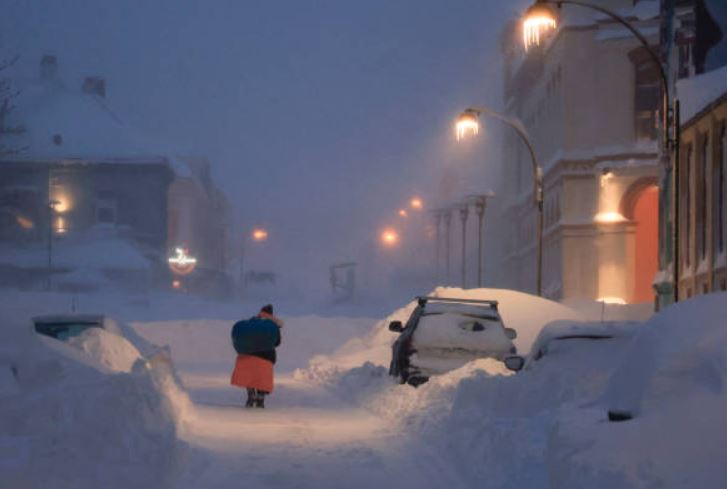
Northeast Braces for Rapid Snowfall and Coastal Transitions in Winter Storm

While the Appalachians and mid-Atlantic experience icy conditions, the Northeast will see rapid snowfall, particularly north and west of Interstate 95. Coastal areas, including New York City and Philadelphia, are expected to transition quickly from snow to rain on Saturday afternoon.
In addition to snow, the southern tail of the storm system could bring strong storms to Florida, with cities like Tampa, Orlando, and Fort Lauderdale facing a risk of damaging winds and brief tornadoes.
By Sunday evening, the storm’s center will move off the New England coast, spreading more snow and wind across the region. Travel delays, slick roadways, and gusty winds are anticipated. Boston, Providence, and Portland could each see up to half a foot of snow, while New York City and Philadelphia may experience a dusting of an inch or two.
The upcoming week brings the potential for another high-impact storm system, affecting various regions from coast to coast. Meteorologists are monitoring the system, which includes a severe thunderstorm threat along the Gulf Coast and a winter weather side with heavy snow, high winds, and possible blizzard conditions in the Plains, Midwest, and Great Lakes. The mid-Atlantic, Northeast, and New England are also at risk of heavy rain and flash flooding.
As winter unfolds, the active weather pattern signals a dynamic start to January, with multiple storms in the forecast, keeping meteorologists and communities on alert.
Read more: Sea Level Rise Mapped: Interactive Tool Shows Submerged Areas Across The United States By 2050