As Hurricane Hilary advanced towards Southern California, the International Space Station (ISS) provided a remarkable vantage point, capturing the storm’s progress on Thursday afternoon, August 17.
The awe-inspiring timelapse footage, sped up 15 times, showcased the eye of the then-Category 2 hurricane.
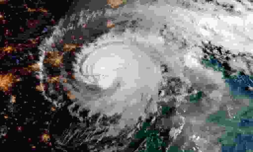
ISS Timelapse Captures Hurricane Hilary’s Intensification
Subsequently, Hurricane Hilary intensified to a Category 4 storm, raising concerns of “significant flooding impacts” in the southwestern United States over the upcoming weekend, according to the National Hurricane Center.
The National Weather Service forecasted that Hilary would reach landfall as a tropical storm close to San Diego around 6 am on Monday, August 21.
The mesmerizing visuals of the storm, captured from the ISS Above/NASA, provided a unique perspective on the meteorological phenomenon’s approach.
Off the coast of Baja California in Mexico, Hurricane Hilary was brewing with increasing intensity. Surveillance from nearby satellites and the International Space Station revealed the hurricane’s massive proportions as it charted a northward course.
Originally forming as a tropical storm off Mexico’s southwest coast on Wednesday, Hilary swiftly elevated to hurricane status by Thursday morning, ultimately intensifying to Category 4 strength.
The International Space Station strategically altered its trajectory to orbit above the storm on Thursday afternoon, yielding a captivating depiction of the storm’s presence on the horizon while it maintained a Category 2 classification.
The accelerated video showcased the immense size of the buzzsaw-like cloud formations gradually emerging over the horizon, culminating as the space station soared above the storm.
Although the video’s playback is sped up to 15 times its actual speed, it offers a remarkable visualization of Hurricane Hilary’s position off the coast of Baja California.
Read more: NASA InSight Observations: Mars’ Rotation Speed Increasing Year By Year
Satellite Imagery Reveals Approaching Storm, Impending Impacts for California

Visible satellite imagery also captured the hurricane’s emergence as the sunrise illuminated the storm in the early hours of Friday morning.
ABC4’s 4Warn Weather Center documented the unfolding scene, beginning from the pitch-black backdrop.
As daylight emerged from the east, it progressively unveiled the clockwise-spinning hurricane surging northward toward California.
Anticipated to make landfall in Baja California around 6 am on Sunday, August 20, Hurricane Hilary is projected to weaken back into a tropical storm by the time it reaches the southern tip of California.
Cities such as Los Angeles and Las Vegas brace for the impact, expecting to bear the brunt of the storm’s wrath with around 2.5 inches of rainfall each.
As the National Hurricane Center has indicated, Los Angeles faces a slight risk of flash flooding, while Las Vegas is at moderate risk.
Residents of southwest Utah cities, including St. George and Cedar City, are also bracing for the aftermath of Hurricane Hilary. Forecasts predict these areas to receive between one to two inches of rainfall, thereby raising concerns of flash flooding from Sunday into Monday.
Amid these anticipated challenges, the ISS’s remarkable footage serves as a testament to the intersection of human technology and the awe-inspiring forces of nature.
Read more: Forever Chemicals’ Contaminate Drinking Water, Raising Alarms For Millions Of Americans